Storm Event
South coast event causing floods from Cornwall to West Sussex, and the Channel Islands
Source
The “Johanna” storm developed over the east coast of the US on 8th March 2008 and travelled northeastward towards the southwest of Greenland. The storm then changed direction and travelled eastward towards the UK, strengthening whilst interacting with another low pressure system over Ireland, before crossing central Ireland and England on 10th March and dissipating in the North Sea on 11th March. The central pressure dropped rapidly to less than 950 mbar. While over Ireland the storm generated strong westerly winds along the coast of southwest England, with gusts of 83 knots [43 m/s] recorded near the Needles, Isle of Wight.
The storm generated a skew surge of between 0.5 and 1.0 m at several sites along the south coast of the UK and in the Bristol Channel and Irish Sea. Water levels exceeded the 1 in 5 year return level at 7 sites, 5 along the south coast. The highest return period water level was at Weymouth and was 1 in 40 years. The next largest return period of 1 in 23 years was at Bournemouth. This event generated the highest recorded water level return periods at three sites, Bournemouth, Weymouth and Milford Haven. The highest skew surge was at Bournemouth and was 0.66 m. At Weymouth the skew surge was 0.53 m. The storm occurred around peak spring tides.
We are unaware of any sources describing the wave conditions during this event
Pathway
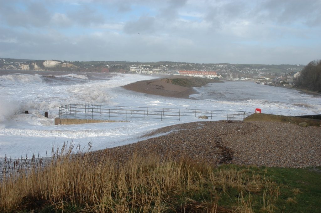
A combination of overtopping and breaching occurred at defences along many areas of the south coast, and more notably in the Solent, Hampshire.
Receptor and Consequence
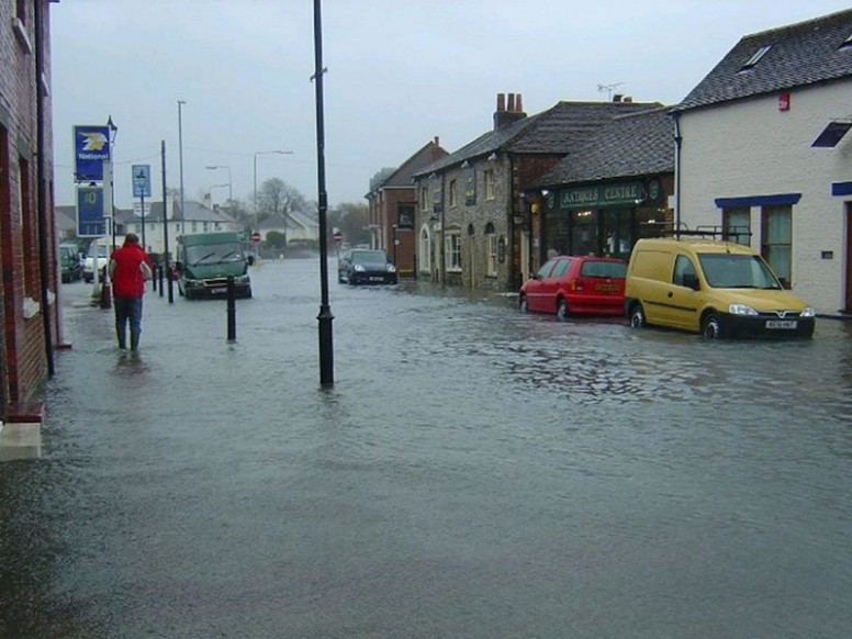
There was a serious event for the south coast with flooding in the western and central Channel including Teignmouth (Devon), Flushing (Cornwall), Portsmouth and other locations in the Solent (Ruocco et al. 2011; Haigh et al. 2015) and South downs regions (Environment Agency, 2010). There was also flooding in several small towns along the Brittany coastline (Le Roy et al. 2014) and the Channel Islands. Flooding was most extensive on the Isle of Wight and in the Channel Islands. The effects were not extreme but there was major wave action and localised sea flooding around the English Channel, most notable at a caravan park on Selsey Bill where around 30 persons were evacuated following a breach of defences. The end of Sandbanks peninsula (in Poole, Dorset) was temporarily cut off from the mainland, and overtopping and much infiltration was reported for Chesil Beach (West 2014). In the Solent the storm caused much erosion at Chilling Cliff near Lee-on-the-Solent and Fareham. In Cornwall, the high spring tides combined with strong winds and a storm surge resulted in flooding at both north and south coasts affecting Bude, Boscastle, Port Gaverne, Port Isaac and Port Quin, Polzeath, Padstow and Trevone, Sladesbridge and Wadebridge, Porth (Newquay), Perranporth, Portreath, Hayle and St Ives, Gweek, Swanpool, Penryn and Mylor Bridge, Tresillian, Fowey, Golant, Lerryn and Lostwithiel, Looe and Saltash. In Fowey, 8 properties were flooded along with 6 in Perranporth where the sea front had to be closed by emergency services. In Polzeath, 3 properties flooded and a road was badly damaged in Port Gaverne. In Port Isaac, at least 7 properties flooded including the life boat station. In Jersey, the damage to defences was estimated at approximately £0.5 million (Le Blancq & Searson, 2008).
Summary Table
| Loss of life | Over a dozen properties flooded in Cornwall |
| Residential property | * |
| Evacuation & rescue | 30 people evacuated from caravan park on Selsey Bill |
| Cost | Damage to sea defences in Jersey estimated at approximately £0.5 million |
| Ports | * |
| Transport | * |
| Energy | * |
| Public services | * |
| Water & wastewater | * |
| Livestock | * |
| Agricultural land | * |
| Coastal erosion | Significant erosion at Chilling Cliff near Lee-on-the-Solent and Fareham |
| Natural environment | * |
| Cultural heritage | * |
| Coastal defences | * |
*No known sources of information available
Affected Sites
| Name | Return Period ? | Water Level ? | Tide ? | Skew Surge ? | Date ? |
|---|---|---|---|---|---|
| WEYMOUTH | 40 | 3.04 | 2.47 | 0.56 | 10th Mar 2008 09:00 |
| BOURNEMOUTH | 23 | 3.09 | 2.42 | 0.66 | 10th Mar 2008 10:30 |
| MILFORD HAVEN | 19 | 8.17 | 7.57 | 0.6 | 10th Mar 2008 07:45 |
| NEWLYN | 15 | 6.34 | 5.89 | 0.45 | 10th Mar 2008 06:15 |
| FISHGUARD | 8 | 5.71 | 5.19 | 0.52 | 10th Mar 2008 08:45 |
| PORTSMOUTH | 7 | 5.49 | 4.91 | 0.58 | 10th Mar 2008 13:00 |
| DEVONPORT | 7 | 6.34 | 5.72 | 0.61 | 10th Mar 2008 07:30 |
We rely on submissions from the public to maintain these images. If you witnessed this event, please help by uploading your photos.

References
- Ruocco, A. Nicholls, R. J., Haigh, I. D., and Wadey, M. (2011). ‘Reconstructing Coastal Flood Occurrence Combining Sea Level and Media Sources: A case study of the Solent UK since 1935’. Natural Hazards, 59(3): 1773-1796. Available at: http://link.springer.com/10.1007/s11069-011-9868-7 (Accessed: 27 March 2015).
- Haigh, I. D., Wadey, M. P., Gallop, S. L., Loehr, H., Nicholls, R. J., Horsburgh, K., Brown, J. M., and Bradshaw, E. (2015). ‘A user-friendly database of coastal flooding in the United Kingdom from 1915–2014’. Scientific Data, 2, p.150021. Available at: http://www.nature.com/articles/sdata201521; [ref title="Wadey et al. 2013"]Wadey, M. P., Nicholls, R. J. and Haigh, I. D. (2013). ‘Understanding a coastal flood event: The 10th March 2008 storm surge event in the Solent, UK’. Natural Hazards, 67(2), pp.829–854
- Environment Agency, (2010). Solent & South Downs Area Report 10 March tidal flooding event, Hampshire & Isle of Wight. A report of events, consequences and conclusions. Version 2.,
- Le Roy, S. et al. (2014). ‘Coastal flooding of urban areas by overtopping: dynamic modelling application to the Johanna storm (2008) in Gâvres (France)’. Natural Hazards and Earth System Sciences Discussions, 2(8), pp.4947–4985
- West, I.W. (2014). Chesil Beach-Hurricanes, Storms, and Storm Surges. Geology of the Wessex Coast of Southern England. Available at: http://www.southampton.ac.uk/~imw/chestorm.htm (Accessed: 8 March 2015)
- Le Blancq, F.W. and Searson, J. (2008). Effects of the 10th March 2008 storm surge on defences in the Channel Islands – unpublished report, Jersey