Storm Event
Coastal towns in southwest England are flooded again after being hit by strong winds, large waves and extreme water levels
Source
The storm developed between Canada and southwest Greenland on 1st February 2014 and moved eastwards towards the UK. South of Iceland the storm combined with, and was enhanced by, an earlier storm located north of the UK, which caused flooding on 1st February. The central pressure deepened to about 950 mbar. The storm turned northwards, then moved west towards Greenland before dissipating close to its area of origin. The storm generated very strong southerly winds reaching 70 knots [36 m/s] along the south coast of the UK (Met Office, 2014). This storm was part of a series of successive storms that moved across the UK, each separated by only a few days (Met Office, 2014).
Skew surge values of between 0.25–1.0 m were recorded at many sites along the UK south and west coasts, where water levels also exceeded the 1 in 5 year return level at 9 sites. The highest return period water level of 1 in 37 years was recorded at Newlyn (which was the highest recorded water level at this site in the almost 100-year dataset). The next largest return period of 1 in 16 years was recorded at Fishguard, where the highest skew surge of 0.66 m was also recorded. At Newlyn, the skew surge was 0.47 m. The event occurred about 2 days after peak spring tides.
Significant wave heights from 6 to 8 m were forecasted for the UK west and south coasts (The Weather Channel, 2014)
Pathway
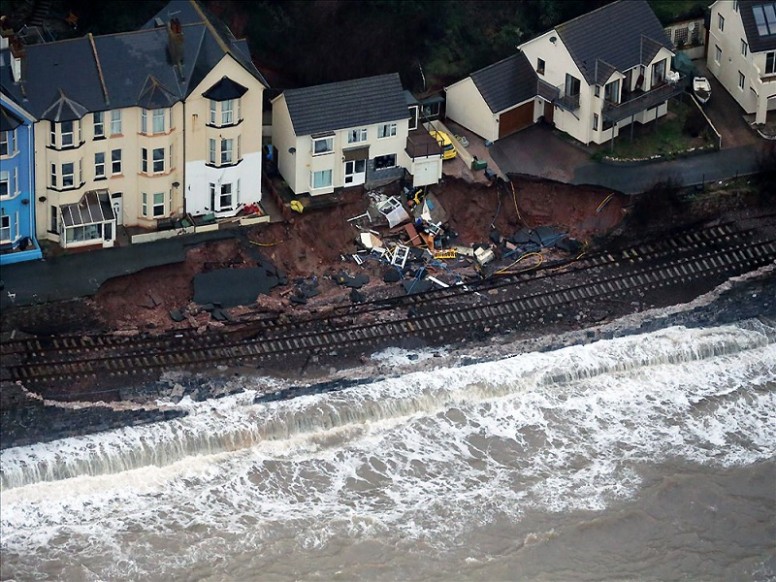
Overtopping of sea defences was the primary mechanism for flooding during this event.
Receptor and Consequence
This event was associated with flooding around the south and southwest coasts, with impacts exacerbated due to the occurrence of several storms and consequent flooding during the preceding days (Haigh et al., 2015). Locations flooded in Cornwall included Looe, Fowey, Newlyn, Porthleven and Mevagissey (BBC, 2014b). The Harbour Master for Looe reported that flood water along nearby streets were too deep for the passage of vehicles (BBC, 2014b). In Devon, parts of Plymouth, Salcombe, Exmouth and Kingsbridge experienced flooding. Also, properties on the Isle of Scilly were reported to be flooded. Amateur video reports also showed coastal flooding at St Mawes (Cornwall), Somerset and Lahinch (Ireland), around 3rd February. Rail services between Penzance and St Erth were suspended due to flooding. In the afternoon of 3rd February, 21 properties remained flooded and 200 people were cut off in the villages of Muchelney, Thorney, Oath, Stathe and North Moor. Considerable flooding occurred in many parts of Bristol after the River Avon rose above its banks (Bristol Culture, 2014). The storms also caused significant coastal erosion in many areas, altering beach profiles.
Summary Table:
| Loss of life | * |
| Residential property | Properties in the Isle of Scilly were flooded |
| Evacuation & rescue | * |
| Cost | * |
| Ports | * |
| Transport | Railway tracks between Penzance and St Erth were affected by flooding |
| Energy | * |
| Public services | * |
| Water & wastewater | * |
| Livestock | * |
| Agricultural land | * |
| Coastal erosion | Significant coastal erosion in many areas, altering beach profiles |
| Natural environment | * |
| Cultural heritage | * |
| Coastal defences | * |
Affected Sites
| Name | Return Period ? | Water Level ? | Tide ? | Skew Surge ? | Date ? |
|---|---|---|---|---|---|
| NEWLYN | 37 | 6.43 | 5.97 | 0.46 | 3rd Feb 2014 07:00 |
| FISHGUARD | 16 | 5.8 | 5.14 | 0.66 | 3rd Feb 2014 09:30 |
| MILFORD HAVEN | 12 | 8.14 | 7.64 | 0.5 | 3rd Feb 2014 08:30 |
| STORNOWAY | 10 | 5.85 | 5.45 | 0.4 | 2nd Feb 2014 08:30 |
| PORTPATRICK | 8 | 4.89 | 4.38 | 0.51 | 3rd Feb 2014 13:45 |
| ILFRACOMBE | 8 | 10.4 | 9.94 | 0.46 | 3rd Feb 2014 08:15 |
| DEVONPORT | 8 | 6.36 | 5.9 | 0.46 | 3rd Feb 2014 08:15 |
| PORT ERIN | 5 | 6.34 | 5.77 | 0.56 | 3rd Feb 2014 13:30 |
| HOLYHEAD | 5 | 6.6 | 6.11 | 0.49 | 3rd Feb 2014 12:30 |
We rely on submissions from the public to maintain these images. If you witnessed this event, please help by uploading your photos.

References
- Met Office, (2014). ‘Winter storms, December 2013 to January 2014’. Met Office. Available at: http://www.metoffice.gov.uk/climate/uk/interesting/2013-decwind (Accessed: 9 September 2015)
- The Weather Channel, (2014). ‘UK Outlook – 1st February to 3rd February 2014’. The Weather Channel. Available at: http://uk.weather.com/story/news/uk-daily-outlook-january-2014-20140123?pageno=4 (Accessed: 18 August 2014)
- Haigh, I. D., Wadey, M. P., Gallop, S. L., Loehr, H., Nicholls, R. J., Horsburgh, K., Brown, J. M., and Bradshaw, E., (2015). ‘A user-friendly database of coastal flooding in the United Kingdom from 1915–2014’. Scientific Data, 2, p.150021. Available at: http://www.nature.com/articles/sdata201521.
- BBC, (2014b). ‘Coastal communities in Devon and Cornwall flooded’. BBC News. Available at: http://www.bbc.co.uk/news/uk-england-26012890 (Accessed: 16 January 2014).
- Bristol Culture, (2014). ‘Today’s flooding in Bristol’. Bristol Culture. Available at: http://www.bristol-culture.com/2014/01/03/todays-flooding-in-bristol/ (Accessed: 16 August 2014).